MATLAB script for 3D visualizing geodata on a rotating globe
For usage examples and a step-by-step tutorial, have a look at the package online manual.
The package is generally described in:
-
Bezděk A, Sebera J, 2013. MATLAB script for 3D visualizing geodata on a rotating globe.
Computers & geosciences 56, 127–130, http://dx.doi.org/10.1016/j.cageo.2013.03.007.
Bezdek_Sebera_2013_MATLAB_script_(preprint).pdf (3 577.5 kB)
-
Bezděk A, Sebera J, 2013.
MATLAB script for visualizing geoid height and other elevation data on rotating 3D globe.
EGU General Assembly, Vienna, Austria, 7–12 April; Geophysical Research Abstracts, Vol. 15, EGU2013-5142.
Bezdek_Sebera_2013_MATLAB_script_(poster).pdf (8 495.8 kB)
Bezdek_Sebera_2013_MATLAB_script_(poster_intro).ppt (72 324.0 kB)
Contents
- Matlab scripts for all the examples
- Data sets for all the examples
- Changing image/animation properties, optional parameters: colour scales, view angle, exaggeration factor, etc.
- Links to external packages and data sets
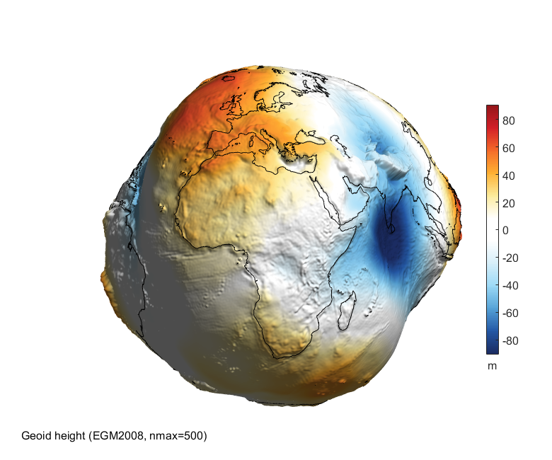
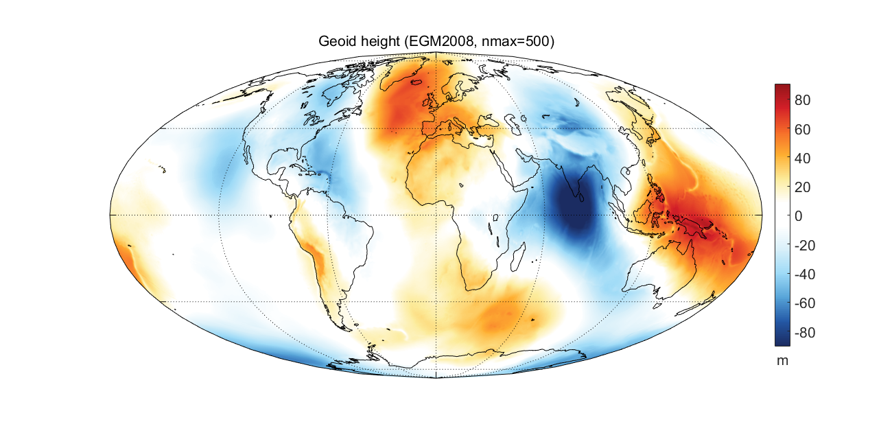
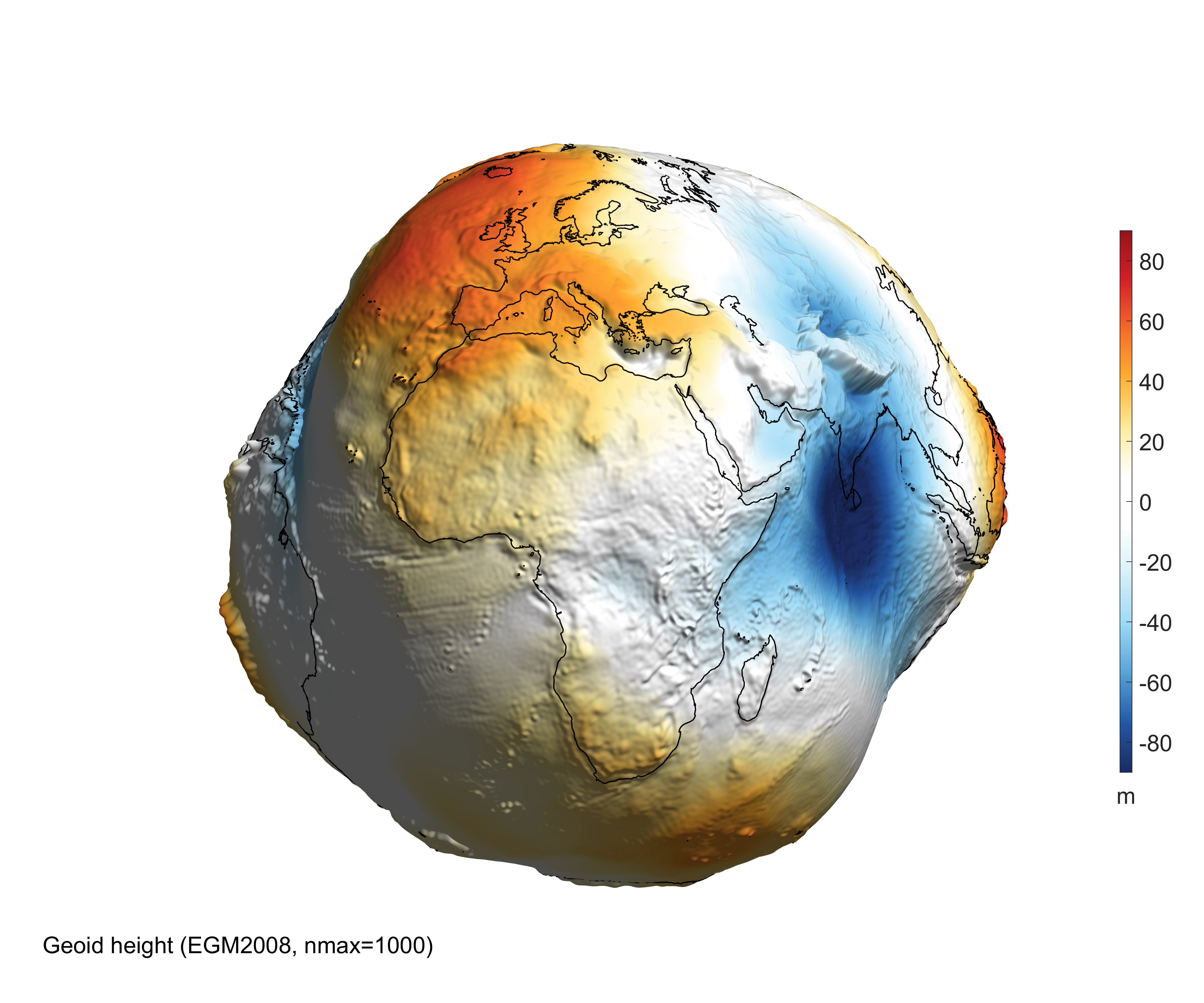
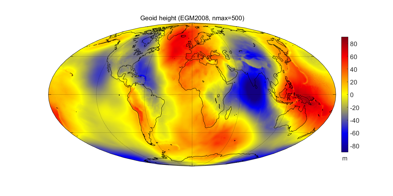
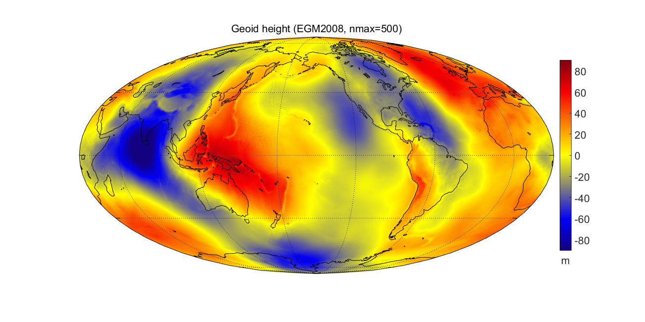
Geoid height
Originally this package was developed for 3D visualizing the geoid height of new global gravity field models.♣ Variations in geoid height are thousand times exaggerated ("Earth potato"), in reality the Earth's shape is very close to a sphere (for more details, see the reference paper).
♣ Clicking on each image displays it in your browser, clicking on the image title will take you to its Matlab code.
Geoid height on 3D globe
 | Geoid height as 2D map
  |
Animation: rotating globe
| High resolution image
 |
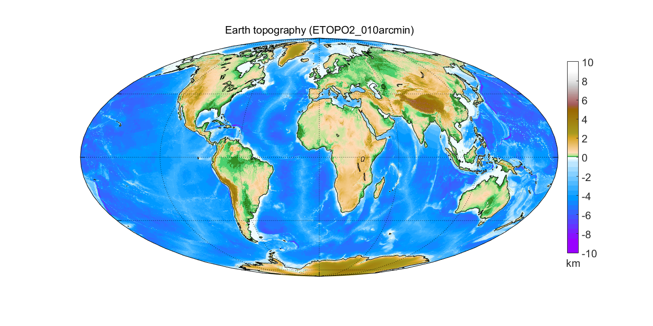
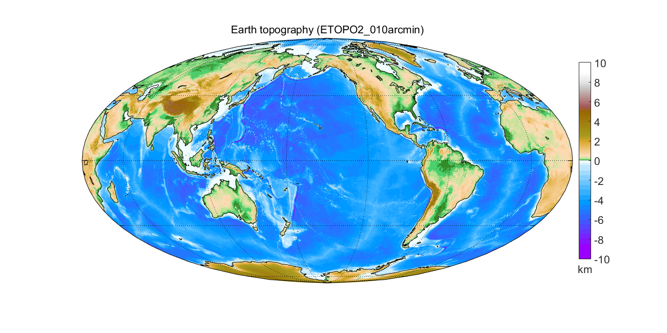
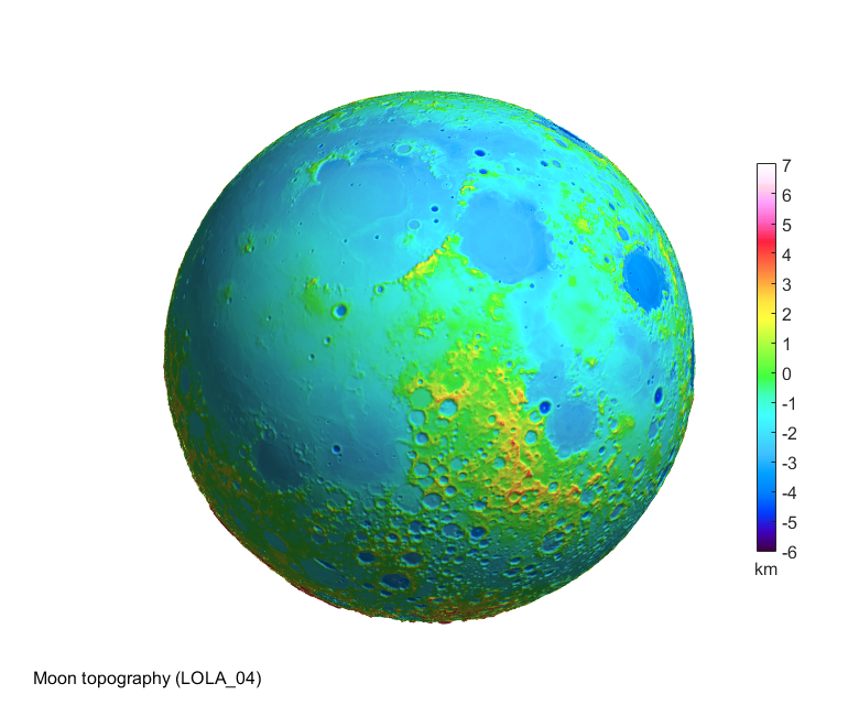
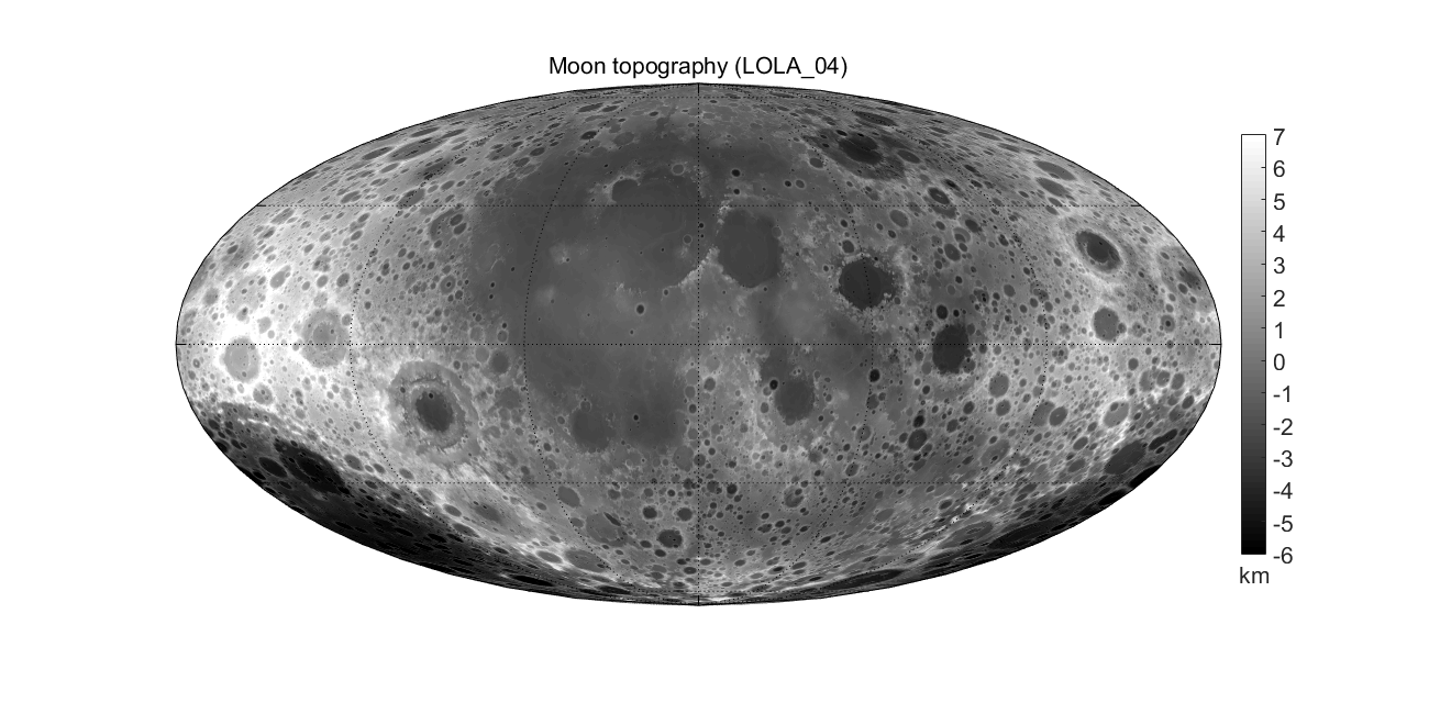
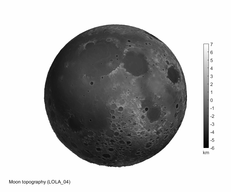
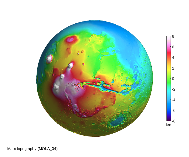
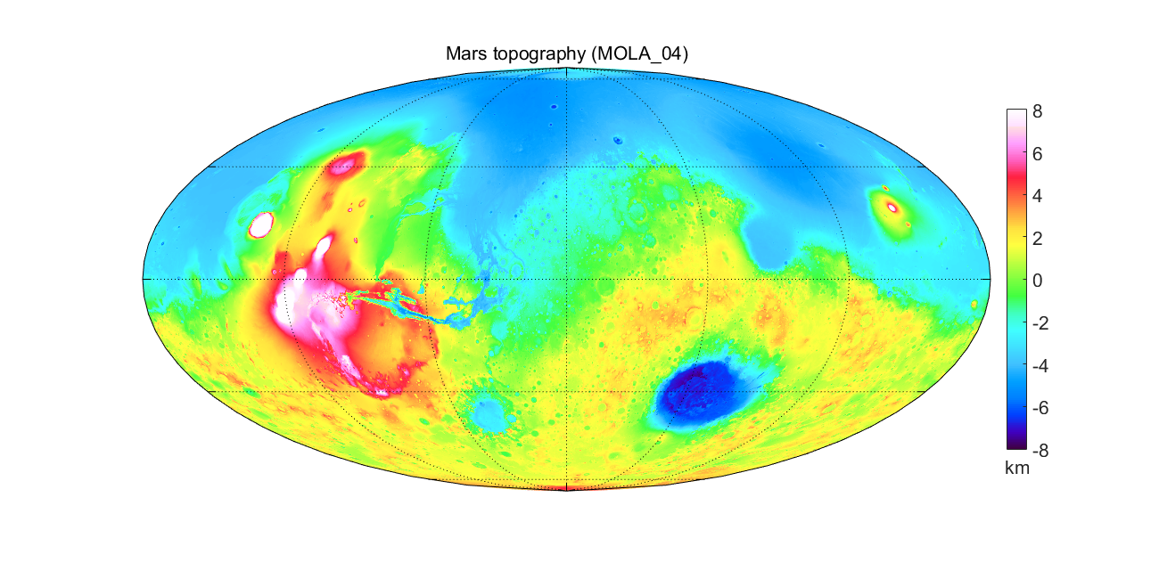
Topography of Earth, Moon, Mars
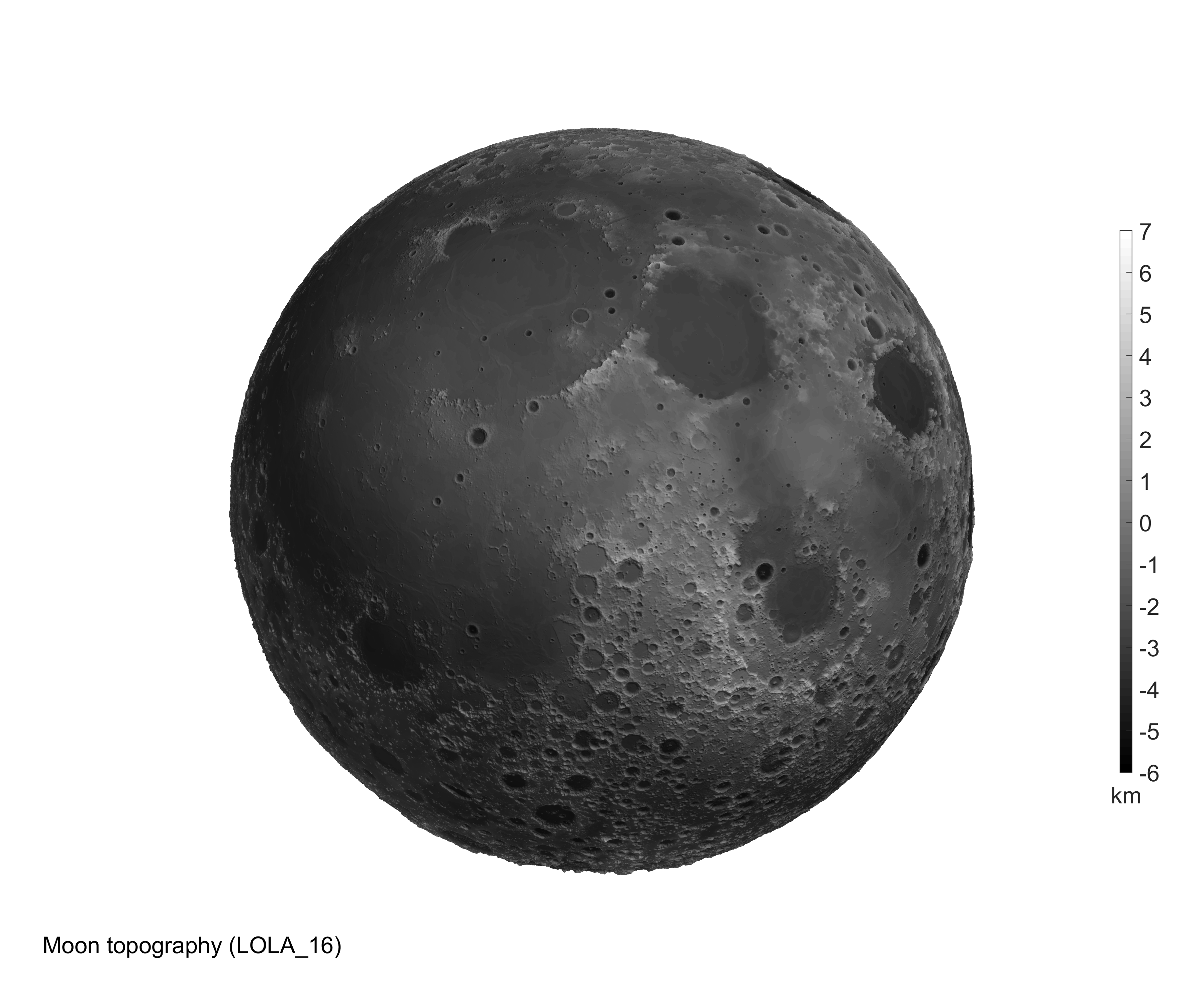
Examples of using the package rotating_3d_globe.zip. With only the basic module of Matlab without any toolbox, one can produce 2D and 3D images of planetary topography using various colour scales and with surprising details (look at high resolution images below).♣ The Moon in greyscale resembles to a photography, although here we visualize altitudes; the Moon does not have an atmosphere, obviously its altitudes correspond rather well to the colouring of its surface.
♣ See also http://en.wikipedia.org/wiki/Topography_of_the_Moon, http://en.wikipedia.org/wiki/Geography_of_Mars.
♣ Clicking on each image displays it in your browser, clicking on the image title will take you to its Matlab code.
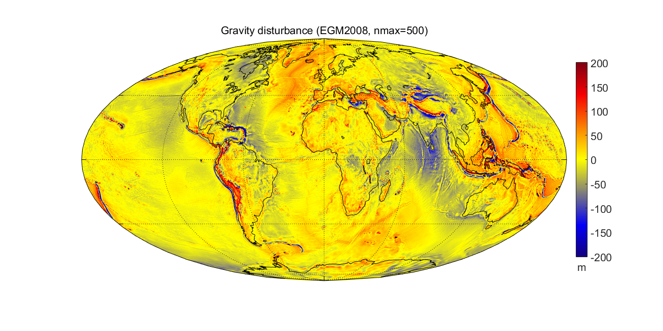
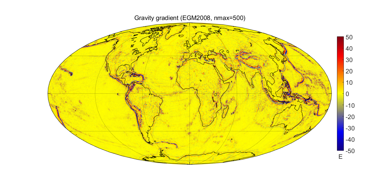
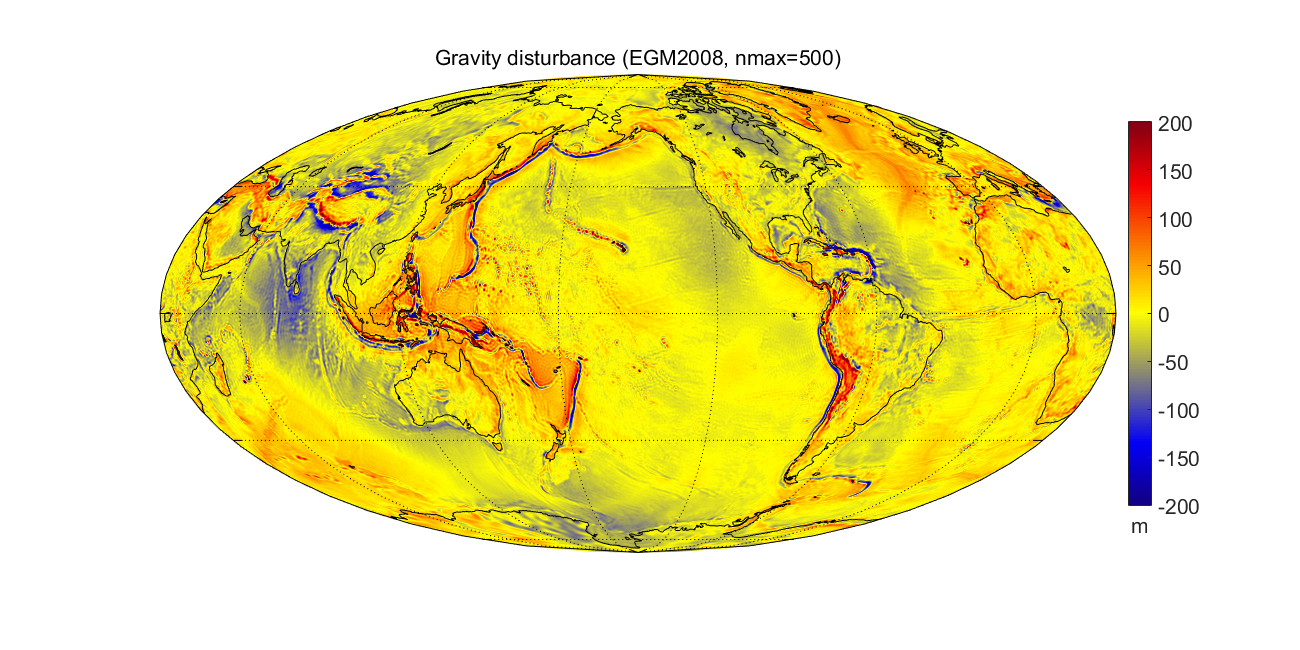
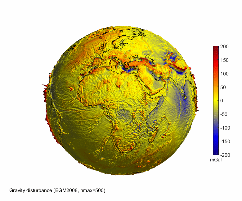
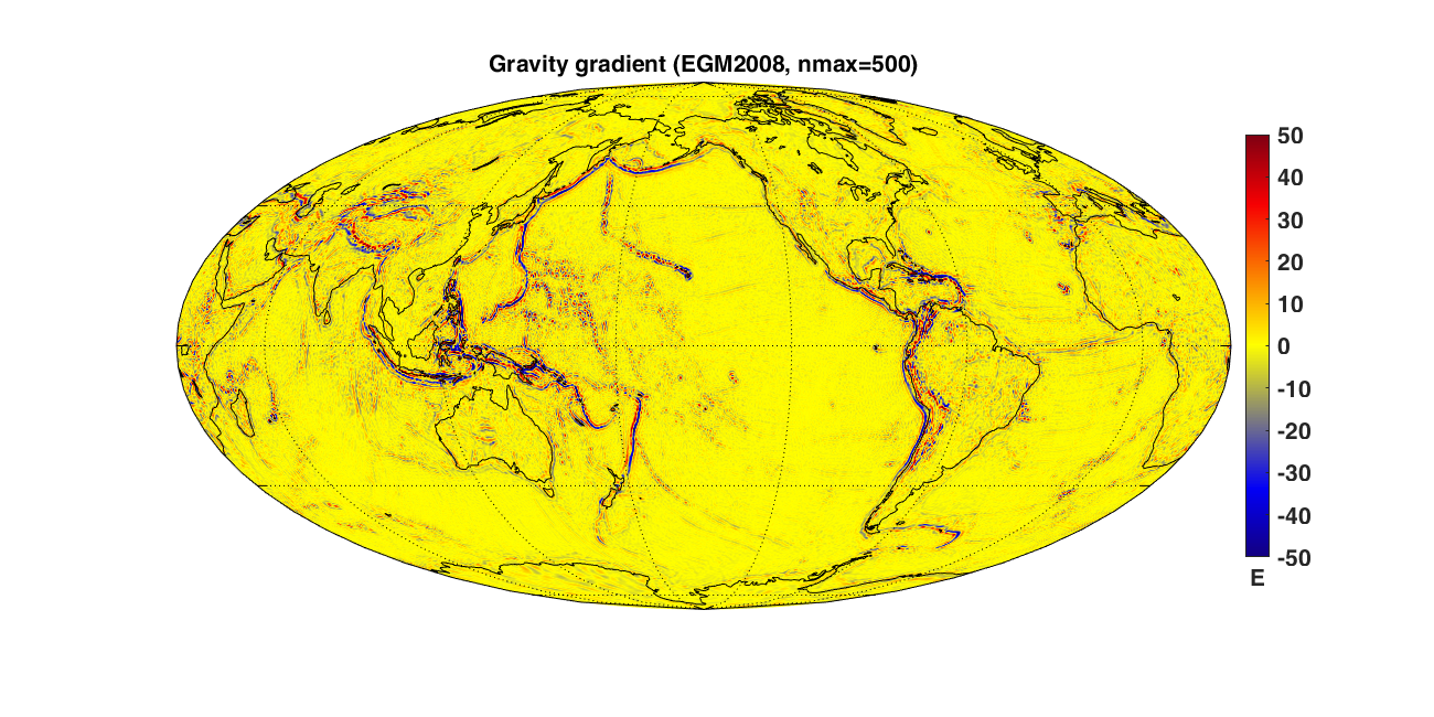
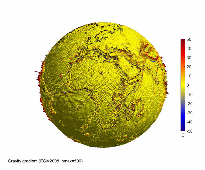
Geoid height, gravity disturbance, gravity gradient
Examples of using this free Matlab package rotating_3d_globe.zip. From left to right, gradually increasing order of differentiation has the effect of amplifying the "waviness" in the quantities shown, which is particularly well illustrated in the 3D images. Here, geoid height is related to Earth gravity potential and gravity disturbance to the first derivative of the potential; and the displayed gravity gradient was computed as the second radial derivative of the disturbing potential. For precise definitions, see the reference paper.♣ Clicking on each image displays it in your browser, clicking on the image title will take you to its Matlab code.
Geoid height
 | Gravity disturbance
 | Gravity gradient
 | ||||||
2D map
 | 2D map
 | 2D map
 | ||||||
|
|
| ||||||
| Geoid height (high resolution) 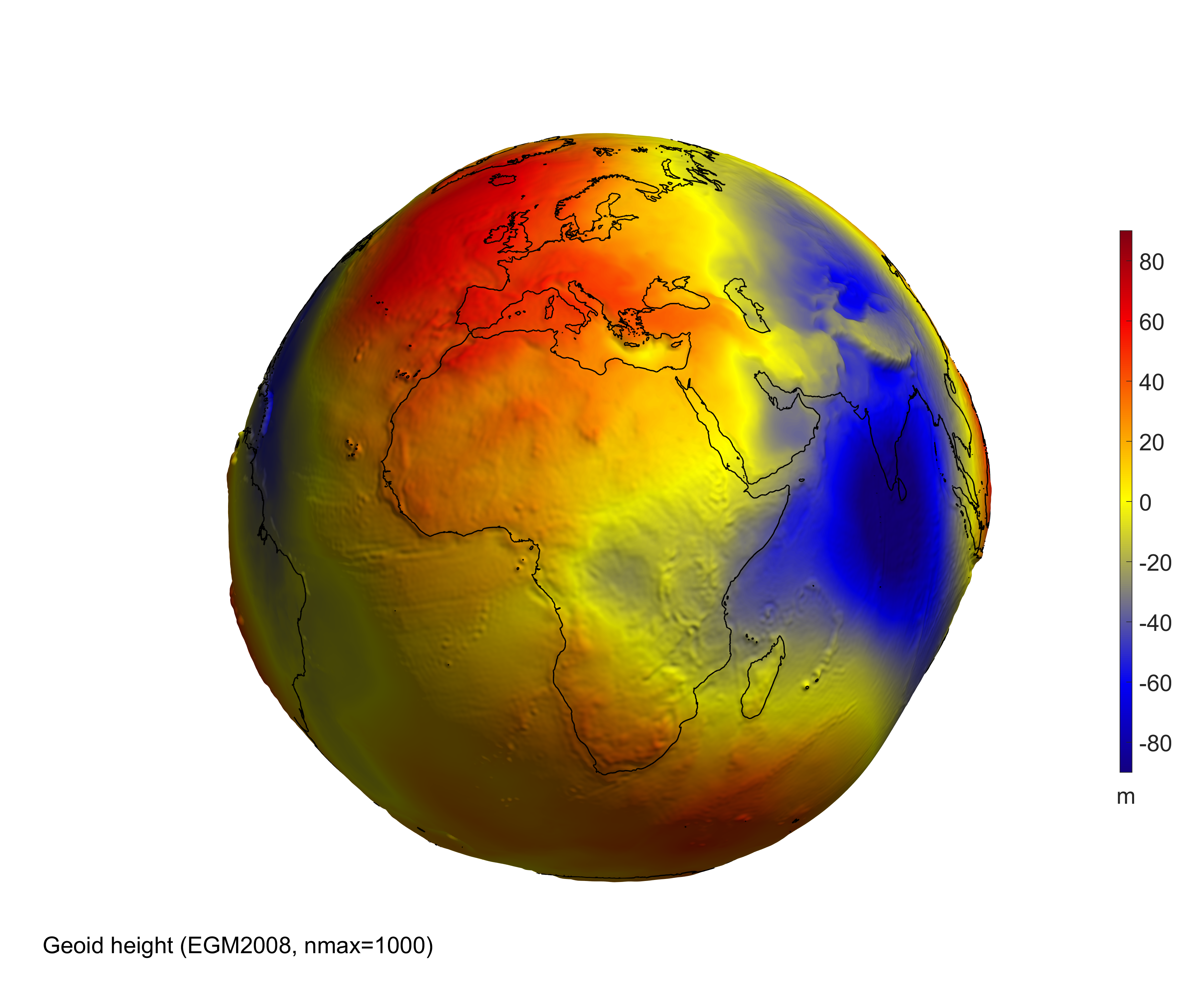 | Gravity disturbance (high resolution) 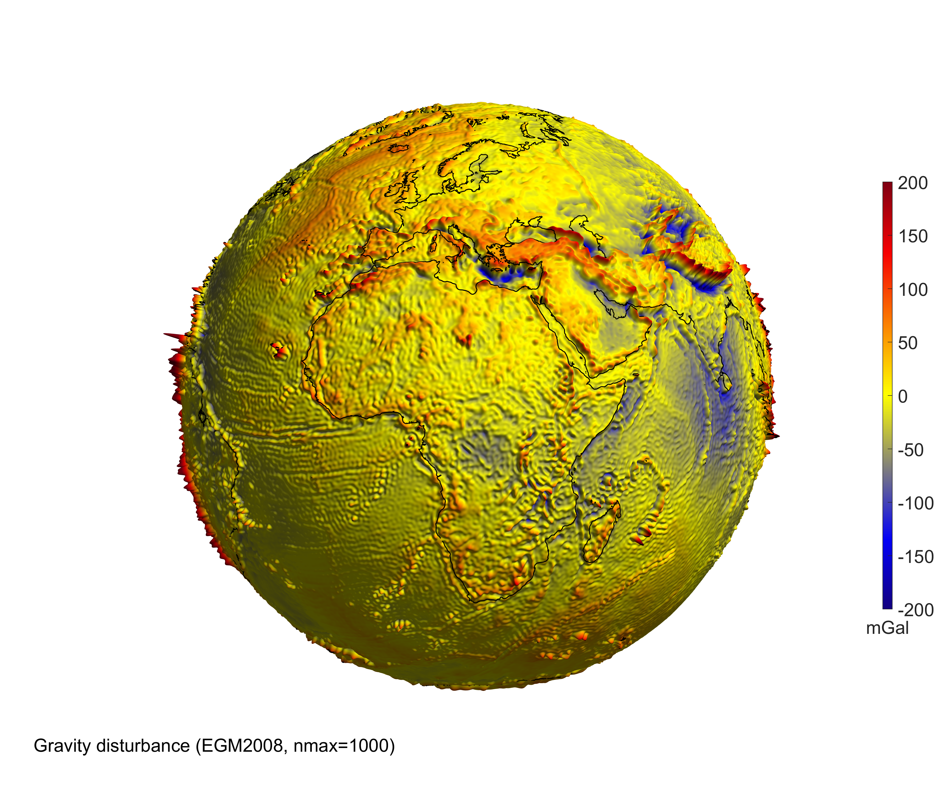 | Gravity gradient (high resolution) 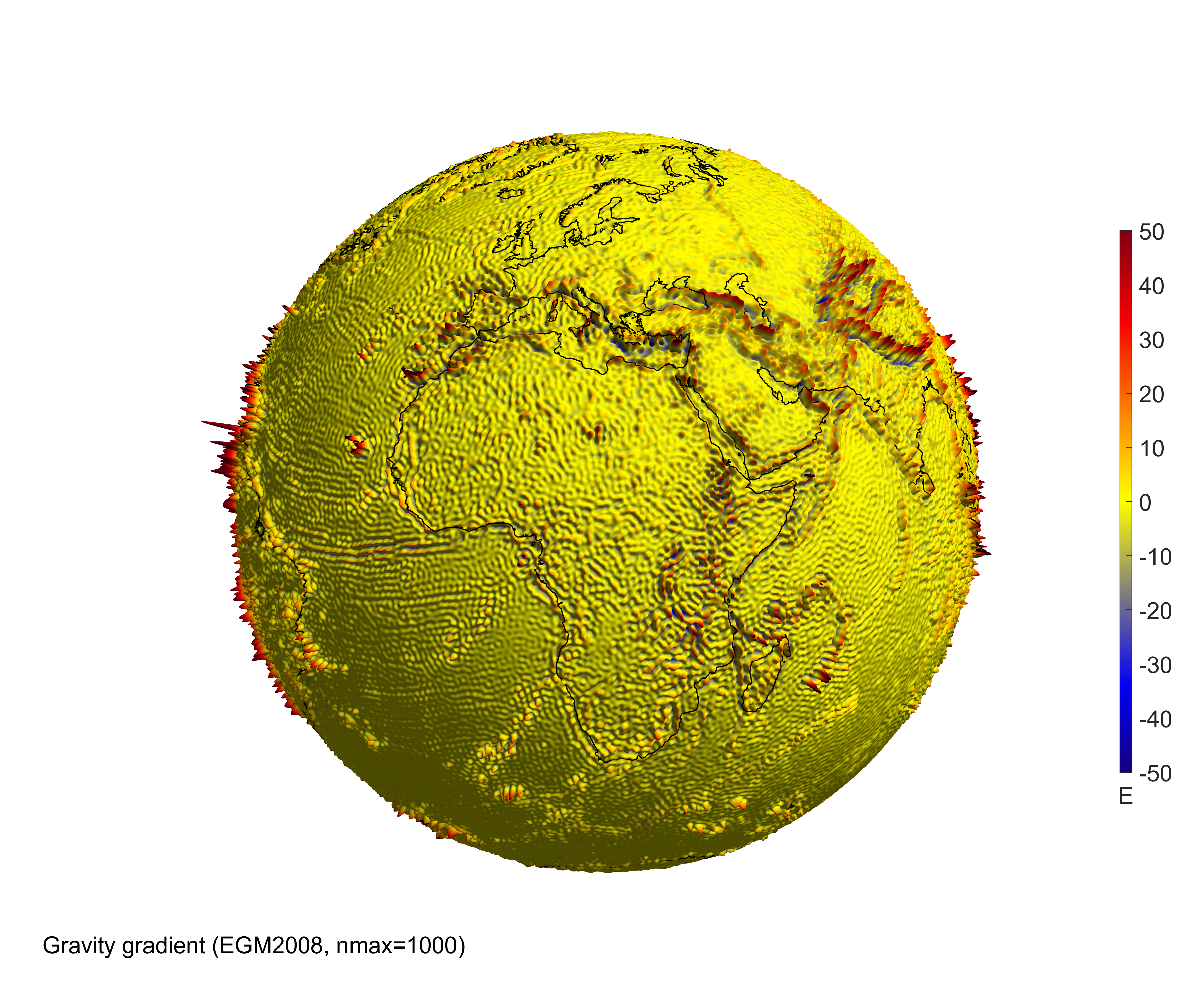 |
Matlab scripts for all the examples
First download the package rotating_3d_globe.zip, unpack it and add it to your Matlab path. A step-by-step manual is included. This package contains also the data for the lower resolution images. For high resolution images, download data_high_resolution.zip (122 MB) separately.♣ To create videos in compressed formats WMV, MP4, xvid AVI, download, install and add to your Matlab path: ffmpeg.
Geoid height on 3D globe
%% Selection of geopotential model and computation/loading of the grid values
model='egm2008';  %nmax=2190
nmax=500;
% Computation of grid for the selected geopotential functional
[lond,latd,gh]=compute_geopot_grids(model,nmax,'functional','gh');

%% Geoid height in 3D as PNG image
   [hc,hlab,name_png]=rotating_3d_globe(lond,latd,gh,'coastlines',1,...
      'exaggeration_factor',1.3e4,'radius',6378e3,'units','m',...
      'graph_label',sprintf('Geoid height (%s, nmax=%d)',upper(model),nmax),...
      'clbr_limits',[-90 90],'clbr_tick',-100:20:100,...
      'cptcmap_pm','BlueWhiteOrangeRed',...
      'preview_figure_visible',1,...
      'window_height',650);
Geoid height as 2D map
%% Selection of geopotential model and computation/loading of the grid values
model='egm2008';  %nmax=2190
nmax=500;
% Computation of grid for the selected geopotential functional
[lond,latd,gh]=compute_geopot_grids(model,nmax,'functional','gh');

%% Geoid height as 2D map
   [hc,htit,name_png]=elevation_2d_map(lond,latd,gh,'coastlines',1,...
      'units','m',...
      'graph_label',sprintf('Geoid height (%s, nmax=%d)',upper(model),nmax),...
      'clbr_limits',[-90 90],'clbr_tick',-100:20:100,...
      'cptcmap_pm','BlueWhiteOrangeRed',...
      'window_height',650);
%% Geoid height as 2D map (centred on the Pacific)
   [hc,htit,name_png]=elevation_2d_map(lond,latd,gh,'coastlines',1,...
      'units','m',...
      'graph_label',sprintf('Geoid height (%s, nmax=%d)',upper(model),nmax),...
      'clbr_limits',[-90 90],'clbr_tick',-100:20:100,...
      'cptcmap_pm','BlueWhiteOrangeRed',...
      'map_center','Pacific',...
      'window_height',650);
Animation: rotating globe as animated GIF
%% Selection of geopotential model and computation/loading of the grid values
model='egm2008';  %nmax=2190
nmax=500;
% Computation of grid for the selected geopotential functional
[lond,latd,gh]=compute_geopot_grids(model,nmax,'functional','gh');

%% Geoid height in 3D as animated GIF
   [hc,hlab,name_png]=rotating_3d_globe(lond,latd,gh,'coastlines',1,...
      'exaggeration_factor',1.3e4,'radius',6378e3,'units','m',...
      'graph_label',sprintf('Geoid height (%s, nmax=%d)',upper(model),nmax),...
      'clbr_limits',[-90 90],'clbr_tick',-100:20:100,...
      'cptcmap_pm','BlueWhiteOrangeRed',...
      'preview_figure_visible',1,'clbr_anim',1,...
      'anim_gif',1,'anim_angle',360,'time_for_360deg',42,'fps',1,...
      'window_height',650);

Animation: rotating globe as WMV video
%% Selection of geopotential model and computation/loading of the grid values
model='egm2008';  %nmax=2190
nmax=500;
% Computation of grid for the selected geopotential functional
[lond,latd,gh]=compute_geopot_grids(model,nmax,'functional','gh');

%% Geoid height in 3D as WMV video
   [hc,hlab,name_png]=rotating_3d_globe(lond,latd,gh,'coastlines',1,...
      'exaggeration_factor',1.3e4,'radius',6378e3,'units','m',...
      'graph_label',sprintf('Geoid height (%s, nmax=%d)',upper(model),nmax),...
      'clbr_limits',[-90 90],'clbr_tick',-100:20:100,...
      'cptcmap_pm','BlueWhiteOrangeRed',...
      'preview_figure_visible',1,'clbr_anim',1,...
      'video_format','wmv','anim_angle',360,'time_for_360deg',42,'fps',1,...
      'window_height',650);
Geoid height on 3D globe: high resolution image
%% Selection of geopotential model and computation/loading of the grid values
model='egm2008';  %nmax=2190
nmax=1000;
% Computation of grid for the selected geopotential functional
[lond,latd,gh]=compute_geopot_grids(model,nmax,'functional','gh');

%% Geoid height in 3D as PNG image (high resolution)
   [hc,hlab,name_png]=rotating_3d_globe(lond,latd,gh,'coastlines',1,...
      'exaggeration_factor',1.3e4,'radius',6378e3,'units','m',...
      'graph_label',sprintf('Geoid height (%s, nmax=%d)',upper(model),nmax),...
      'clbr_limits',[-90 90],'clbr_tick',-100:20:100,...
      'cptcmap_pm','BlueWhiteOrangeRed',...
      'font_size',18,...
      'window_height',3000);
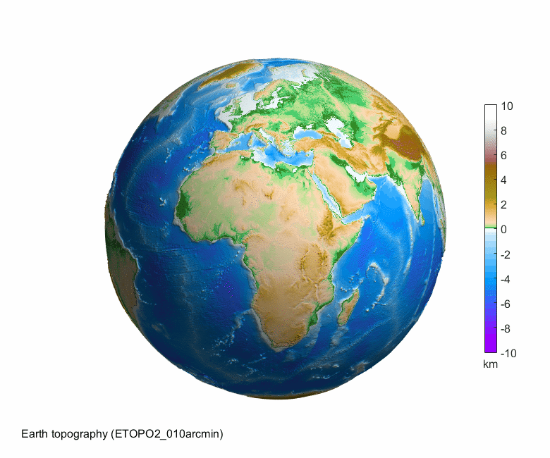
Topography of Earth
%% Selection of Earth topographical data
model='ETOPO2_010arcmin';
fprintf('Loading Earth data: %s\n',model);
load (model);

%% Earth topography in 3D as PNG image
   [hc,hlab,name_png]=rotating_3d_globe(lond_etopo2,latd_etopo2,elev_etopo2_km,'coastlines',0,...
      'exaggeration_factor',13,'radius',6378,'units','km',...
      'graph_label',sprintf('Earth topography (%s)',model),...
      'clbr_limits',[-10 10],'clbr_tick',-10:2:10,...
      'cptcmap_pm','GMT_globe',...
      'preview_figure_visible',1,...
      'window_height',650);

Earth topography as 2D map
%% Selection of Earth topographical data
model='ETOPO2_010arcmin';
fprintf('Loading Earth data: %s\n',model);
load (model);

%% Earth topography as 2D map
   [hc,htit,name_png]=elevation_2d_map(lond_etopo2,latd_etopo2,elev_etopo2_km,'coastlines',1,...
      'units','km',...
      'graph_label',sprintf('Earth topography (%s)',model),...
      'clbr_limits',[-10 10],'clbr_tick',-10:2:10,...
      'cptcmap_pm','GMT_globe',...
      'preview_figure_visible',1,...
      'window_height',650);
%% Earth topography as 2D map (centred on the Pacific)
   [hc,htit,name_png]=elevation_2d_map(lond_etopo2,latd_etopo2,elev_etopo2_km,'coastlines',1,...
      'units','km',...
      'graph_label',sprintf('Earth topography (%s)',model),...
      'clbr_limits',[-10 10],'clbr_tick',-10:2:10,...
      'cptcmap_pm','GMT_globe',...
      'map_center','Pacific',...
      'window_height',650);
Animation: rotating globe as animated GIF
%% Selection of Earth topographical data
model='ETOPO2_010arcmin';
fprintf('Loading Earth data: %s\n',model);
load (model);

%% Earth topography in 3D as animated GIF
   [hc,hlab,name_png]=rotating_3d_globe(lond_etopo2,latd_etopo2,elev_etopo2_km,'coastlines',0,...
      'exaggeration_factor',13,'radius',6378,'units','km',...
      'graph_label',sprintf('Earth topography (%s)',model),...
      'clbr_limits',[-10 10],'clbr_tick',-10:2:10,...
      'cptcmap_pm','GMT_globe',...
      'preview_figure_visible',1,'clbr_anim',1,...
      'anim_gif',1,'anim_angle',360,'time_for_360deg',42,'fps',1,...
      'window_height',650);
Animation: rotating globe as WMV video
%% Selection of Earth topographical data
model='ETOPO2_010arcmin';
fprintf('Loading Earth data: %s\n',model);
load (model);

%% Earth topography in 3D as WMV video
   [hc,hlab,name_png]=rotating_3d_globe(lond_etopo2,latd_etopo2,elev_etopo2_km,'coastlines',0,...
      'exaggeration_factor',13,'radius',6378,'units','km',...
      'graph_label',sprintf('Earth topography (%s)',model),...
      'clbr_limits',[-10 10],'clbr_tick',-10:2:10,...
      'cptcmap_pm','GMT_globe',...
      'preview_figure_visible',1,'clbr_anim',1,...
      'video_format','wmv','anim_angle',360,'time_for_360deg',42,'fps',1,...
      'window_height',650);
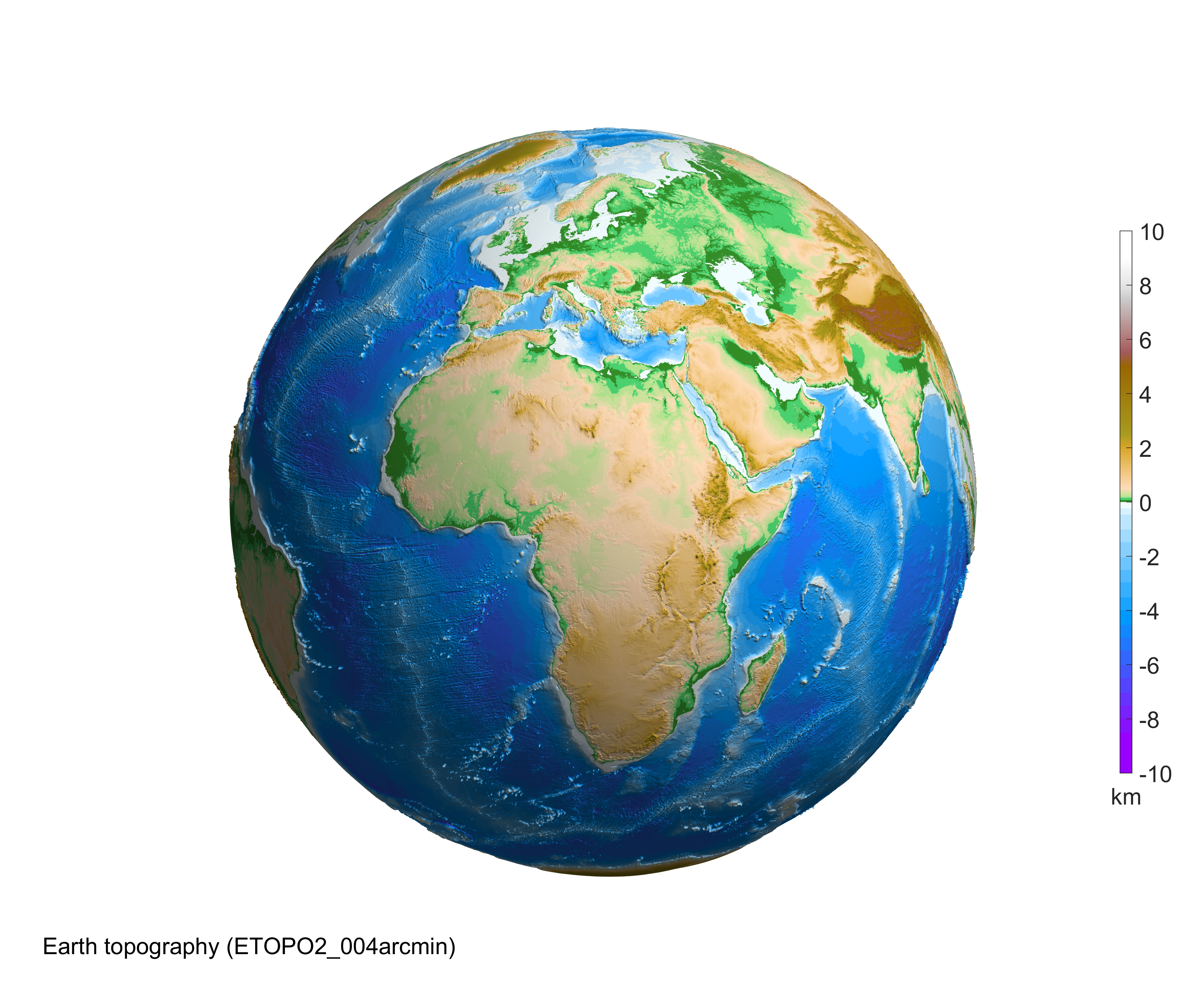
Topography of Earth: high resolution image
%% Selection of Earth topographical data
   if exist('ETOPO2_004arcmin.mat','file')
      model='ETOPO2_004arcmin';  % RAM of 4 GB is necessary
   else
      model='ETOPO2_010arcmin';
   end
   fprintf('Loading Earth data: %s\n',model);
   load (model);

%% Earth topography in 3D as PNG image (high resolution)
   [hc,hlab,name_png]=rotating_3d_globe(lond_etopo2,latd_etopo2,elev_etopo2_km,'coastlines',0,...
      'exaggeration_factor',13,'radius',6378,'units','km',...
      'graph_label',sprintf('Earth topography (%s)',model),...
      'clbr_limits',[-10 10],'clbr_tick',-10:2:10,...
      'cptcmap_pm','GMT_globe',...
      'preview_figure_visible',1,...
      'font_size',18,...
      'window_height',3000);
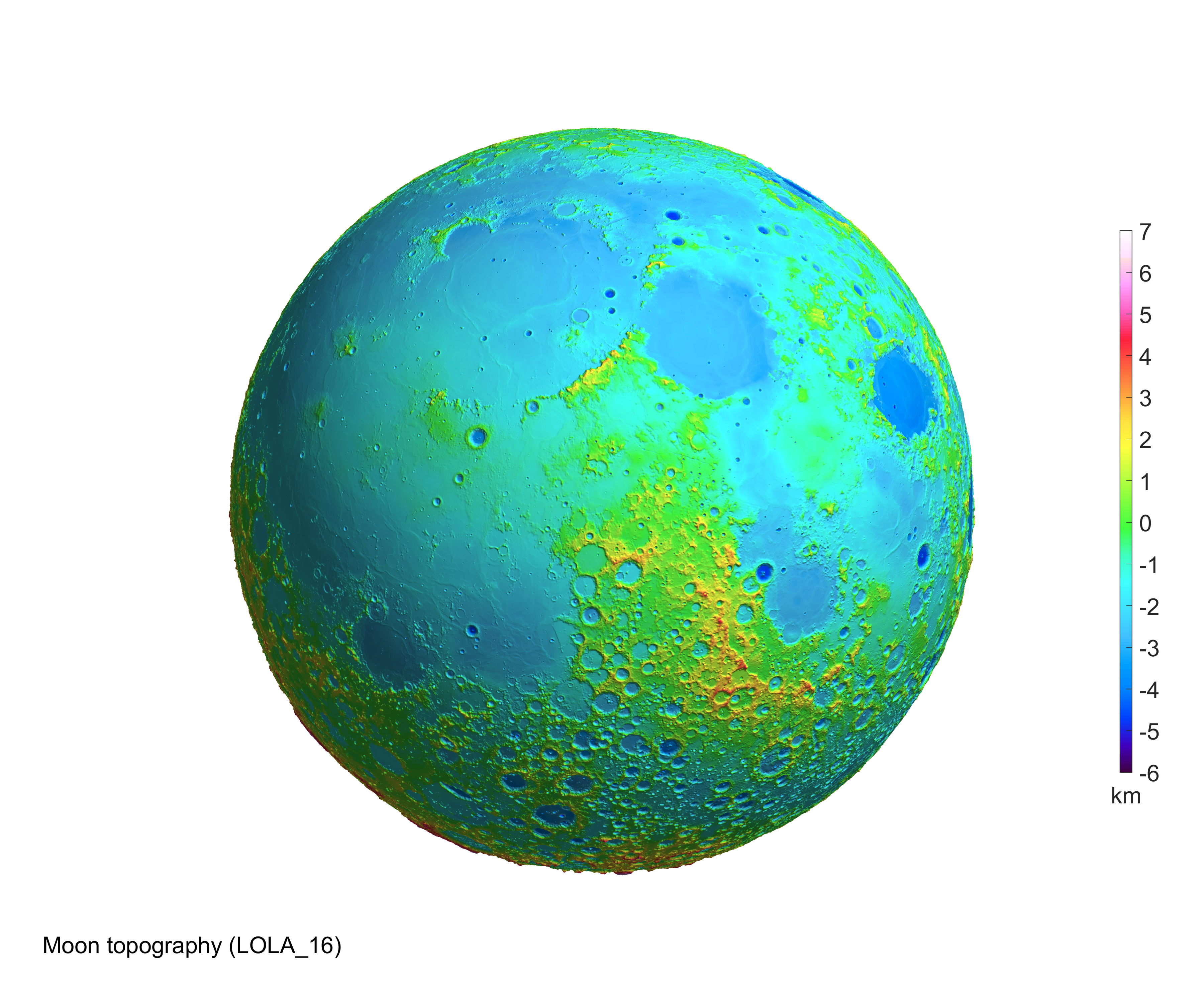
Topography of Moon
%% Selection of Moon topographical data
model='LOLA_04';  %resolution: 1/4 degree = 15 arcmin
fprintf('Loading Moon data: %s\n',model);
load (model);

%% Moon topography in 3D as PNG image
   [hc,hlab,name_png]=rotating_3d_globe(lond_moon,latd_moon,elev_moon_km,...
      'exaggeration_factor',13,'radius',6378,'units','km',...
      'graph_label',sprintf('Moon topography (%s)',model),...
      'clbr_limits',[-6 7],'clbr_tick',-10:10,...
      'cptcmap_pm','GMT_wysiwygcont',...
      'azimuth',90,'elevation',0,...
      'preview_figure_visible',1,...
      'window_height',650);
Moon topography as 2D map
%% Selection of Moon topographical data
model='LOLA_04';  %resolution: 1/4 degree = 15 arcmin
fprintf('Loading Moon data: %s\n',model);
load (model);

%% Moon topography as 2D map
   [hc,htit,name_png]=elevation_2d_map(lond_moon,latd_moon,elev_moon_km,...
      'units','km',...
      'graph_label',sprintf('Moon topography (%s)',model),...
      'clbr_limits',[-6 7],'clbr_tick',-10:10,...
      'cptcmap_pm','GMT_wysiwygcont',...
      'preview_figure_visible',1,...
      'window_height',650);

Animation: rotating globe as animated GIF
%% Selection of Moon topographical data
model='LOLA_04';  %resolution: 1/4 degree = 15 arcmin
fprintf('Loading Moon data: %s\n',model);
load (model);

%% Moon topography in 3D as animated GIF
   [hc,hlab,name_png]=rotating_3d_globe(lond_moon,latd_moon,elev_moon_km,...
      'exaggeration_factor',13,'radius',6378,'units','km',...
      'graph_label',sprintf('Moon topography (%s)',model),...
      'clbr_limits',[-6 7],'clbr_tick',-10:10,...
      'cptcmap_pm','GMT_wysiwygcont',...
      'azimuth',90,'elevation',0,...
      'preview_figure_visible',1,'clbr_anim',1,...
      'anim_gif',1,'anim_angle',360,'time_for_360deg',4,'fps',.5,...
      'window_height',650);

Animation: rotating globe as WMV video
%% Selection of Moon topographical data
model='LOLA_04';  %resolution: 1/4 degree = 15 arcmin
fprintf('Loading Moon data: %s\n',model);
load (model);

%% Moon topography in 3D as WMV video
   [hc,hlab,name_png]=rotating_3d_globe(lond_moon,latd_moon,elev_moon_km,...
      'exaggeration_factor',13,'radius',6378,'units','km',...
      'graph_label',sprintf('Moon topography (%s)',model),...
      'clbr_limits',[-6 7],'clbr_tick',-10:10,...
      'cptcmap_pm','GMT_wysiwygcont',...
      'azimuth',90,'elevation',0,...
      'preview_figure_visible',1,'clbr_anim',1,...
      'video_format','wmv','anim_angle',360,'time_for_360deg',4,'fps',.5,...
      'window_height',650);
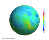
Topography of Moon: high resolution image
%% Selection of Moon topographical data
   if exist('LOLA_16.mat','file')
      model='LOLA_16';  %resolution: 1/16 degree = 3.75 arcmin; RAM of 4 GB is necessary
   else
      model='LOLA_04';  %resolution: 1/4 degree = 15 arcmin
   end
   fprintf('Loading Moon data: %s\n',model);
   load (model);

%% Moon topography in 3D as PNG image (high resolution)
   [hc,hlab,name_png]=rotating_3d_globe(lond_moon,latd_moon,elev_moon_km,...
      'exaggeration_factor',13,'radius',6378,'units','km',...
      'graph_label',sprintf('Moon topography (%s)',model),...
      'clbr_limits',[-6 7],'clbr_tick',-10:10,...
      'cptcmap_pm','GMT_wysiwygcont',...
      'azimuth',90,'elevation',0,...
      'preview_figure_visible',1,...
      'font_size',18,...
      'window_height',3000);
Topography of Moon
%% Selection of Moon topographical data
model='LOLA_04';  %resolution: 1/4 degree = 15 arcmin
fprintf('Loading Moon data: %s\n',model);
load (model);

%% Moon topography in 3D as PNG image
   [hc,hlab,name_png]=rotating_3d_globe(lond_moon,latd_moon,elev_moon_km,...
      'exaggeration_factor',13,'radius',6378,'units','km',...
      'graph_label',sprintf('Moon topography (%s)',model),...
      'clbr_limits',[-6 7],'clbr_tick',-10:10,...
      'clrmap','gray',...
      'azimuth',90,'elevation',0,...
      'preview_figure_visible',1,...
      'window_height',650);

Moon topography as 2D map
%% Selection of Moon topographical data
model='LOLA_04';  %resolution: 1/4 degree = 15 arcmin
fprintf('Loading Moon data: %s\n',model);
load (model);

%% Moon topography as 2D map
   [hc,htit,name_png]=elevation_2d_map(lond_moon,latd_moon,elev_moon_km,...
      'units','km',...
      'graph_label',sprintf('Moon topography (%s)',model),...
      'clbr_limits',[-6 7],'clbr_tick',-10:10,...
      'clrmap','gray',...
      'preview_figure_visible',1,...
      'window_height',650);
Animation: rotating globe as animated GIF
%% Selection of Moon topographical data
model='LOLA_04';  %resolution: 1/4 degree = 15 arcmin
fprintf('Loading Moon data: %s\n',model);
load (model);

%% Moon topography in 3D as animated GIF
   [hc,hlab,name_png]=rotating_3d_globe(lond_moon,latd_moon,elev_moon_km,...
      'exaggeration_factor',13,'radius',6378,'units','km',...
      'graph_label',sprintf('Moon topography (%s)',model),...
      'clbr_limits',[-6 7],'clbr_tick',-10:10,...
      'clrmap','gray',...
      'azimuth',90,'elevation',0,...
      'preview_figure_visible',1,'clbr_anim',1,...
      'anim_gif',1,'anim_angle',360,'time_for_360deg',4,'fps',.5,...
      'window_height',650);
Animation: rotating globe as WMV video
%% Selection of Moon topographical data
model='LOLA_04';  %resolution: 1/4 degree = 15 arcmin
fprintf('Loading Moon data: %s\n',model);
load (model);

%% Moon topography in 3D as WMV video
   [hc,hlab,name_png]=rotating_3d_globe(lond_moon,latd_moon,elev_moon_km,...
      'exaggeration_factor',13,'radius',6378,'units','km',...
      'graph_label',sprintf('Moon topography (%s)',model),...
      'clbr_limits',[-6 7],'clbr_tick',-10:10,...
      'clrmap','gray',...
      'azimuth',90,'elevation',0,...
      'preview_figure_visible',1,'clbr_anim',1,...
      'video_format','wmv','anim_angle',360,'time_for_360deg',4,'fps',.5,...
      'window_height',650);
Topography of Moon: high resolution image
%% Selection of Moon topographical data
   if exist('LOLA_16.mat','file')
      model='LOLA_16';  %resolution: 1/16 degree = 3.75 arcmin; RAM of 4 GB is necessary
   else
      model='LOLA_04';  %resolution: 1/4 degree = 15 arcmin
   end
   fprintf('Loading Moon data: %s\n',model);
   load (model);

%% Moon topography in 3D as PNG image (high resolution)
   [hc,hlab,name_png]=rotating_3d_globe(lond_moon,latd_moon,elev_moon_km,...
      'exaggeration_factor',13,'radius',6378,'units','km',...
      'graph_label',sprintf('Moon topography (%s)',model),...
      'clbr_limits',[-6 7],'clbr_tick',-10:10,...
      'clrmap','gray',...
      'azimuth',90,'elevation',0,...
      'preview_figure_visible',1,...
      'font_size',18,...
      'window_height',3000);
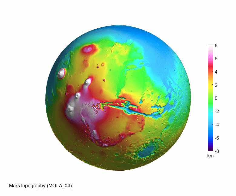
Topography of Mars
%% Selection of Mars topographical data
model='MOLA_04';  %resolution: 1/4 degree = 15 arcmin
fprintf('Loading Mars data: %s\n',model);
load (model);

%% Mars topography in 3D as PNG image
   [hc,hlab,name_png]=rotating_3d_globe(lond_Mars,latd_Mars,elev_Mars_km,...
      'exaggeration_factor',10,'radius',3400,'units','km',...
      'graph_label',sprintf('Mars topography (%s)',model),...
      'clbr_limits',[-8 8],'clbr_tick',-10:2:10,...
      'cptcmap_pm','GMT_wysiwygcont',...
      'azimuth',10,'elevation',0,...
      'preview_figure_visible',1,...
      'window_height',650);
Mars topography as 2D map
%% Selection of Mars topographical data
model='MOLA_04';  %resolution: 1/4 degree = 15 arcmin
fprintf('Loading Mars data: %s\n',model);
load (model);

%% Mars topography as 2D map
   [hc,htit,name_png]=elevation_2d_map(lond_Mars,latd_Mars,elev_Mars_km,...
      'units','km',...
      'graph_label',sprintf('Mars topography (%s)',model),...
      'clbr_limits',[-8 8],'clbr_tick',-10:2:10,...
      'cptcmap_pm','GMT_wysiwygcont',...
      'preview_figure_visible',1,...
      'window_height',650);
Animation: rotating globe as animated GIF
%% Selection of Mars topographical data
model='MOLA_04';  %resolution: 1/4 degree = 15 arcmin
fprintf('Loading Mars data: %s\n',model);
load (model);

%% Mars topography in 3D as animated GIF
   [hc,hlab,name_png]=rotating_3d_globe(lond_Mars,latd_Mars,elev_Mars_km,...
      'exaggeration_factor',10,'radius',3400,'units','km',...
      'graph_label',sprintf('Mars topography (%s)',model),...
      'clbr_limits',[-8 8],'clbr_tick',-10:2:10,...
      'cptcmap_pm','GMT_wysiwygcont',...
      'azimuth',10,'elevation',0,...
      'preview_figure_visible',1,'clbr_anim',1,...
      'anim_gif',1,'anim_angle',360,'time_for_360deg',42,'fps',1,...
      'window_height',650);
Animation: rotating globe as WMV video
%% Selection of Mars topographical data
model='MOLA_04';  %resolution: 1/4 degree = 15 arcmin
fprintf('Loading Mars data: %s\n',model);
load (model);

%% Mars topography in 3D as WMV video
   [hc,hlab,name_png]=rotating_3d_globe(lond_Mars,latd_Mars,elev_Mars_km,...
      'exaggeration_factor',10,'radius',3400,'units','km',...
      'graph_label',sprintf('Mars topography (%s)',model),...
      'clbr_limits',[-8 8],'clbr_tick',-10:2:10,...
      'cptcmap_pm','GMT_wysiwygcont',...
      'azimuth',10,'elevation',0,...
      'preview_figure_visible',1,'clbr_anim',1,...
      'video_format','wmv','anim_angle',360,'time_for_360deg',42,'fps',1,...
      'window_height',650);
Topography of Mars: high resolution image
%% Selection of Mars topographical data
   if exist('MOLA_16.mat','file')
      model='MOLA_16';  %resolution: 1/16 degree = 3.75 arcmin; RAM of 4 GB is necessary
   else
      model='MOLA_04';  %resolution: 1/4 degree = 15 arcmin
   end
   fprintf('Loading Mars data: %s\n',model);
   load (model);

%% Mars topography in 3D as PNG image (high resolution)
   [hc,hlab,name_png]=rotating_3d_globe(lond_Mars,latd_Mars,elev_Mars_km,...
      'exaggeration_factor',10,'radius',3400,'units','km',...
      'graph_label',sprintf('Mars topography (%s)',model),...
      'clbr_limits',[-8 8],'clbr_tick',-10:2:10,...
      'cptcmap_pm','GMT_wysiwygcont',...
      'azimuth',10,'elevation',0,...
      'preview_figure_visible',1,...
      'font_size',18,...
      'window_height',3000);

Geoid height on 3D globe
%% Selection of geopotential model and computation/loading of the grid values
model='egm2008';  %nmax=2190
nmax=500;
% Computation of grid for the selected geopotential functional
[lond,latd,gh]=compute_geopot_grids(model,nmax,'functional','gh');

%% Geoid height in 3D as PNG image
   [hc,hlab,name_png]=rotating_3d_globe(lond,latd,gh,'coastlines',1,...
      'exaggeration_factor',1,'radius',5e3/4,'units','m',...
      'graph_label',sprintf('Geoid height (%s, nmax=%d)',upper(model),nmax),...
      'clbr_limits',[-90 90],'clbr_tick',-100:20:100,...
      'clrmap','clrmap_byr1',...
      'preview_figure_visible',1,...
      'window_height',650);
Geoid height as 2D map
%% Selection of geopotential model and computation/loading of the grid values
model='egm2008';  %nmax=2190
nmax=500;
% Computation of grid for the selected geopotential functional
[lond,latd,gh]=compute_geopot_grids(model,nmax,'functional','gh');

%% Geoid height as 2D map
   [hc,htit,name_png]=elevation_2d_map(lond,latd,gh,'coastlines',1,...
      'units','m',...
      'graph_label',sprintf('Geoid height (%s, nmax=%d)',upper(model),nmax),...
      'clbr_limits',[-90 90],'clbr_tick',-100:20:100,...
      'clrmap','clrmap_byr1',...
      'window_height',650);
%% Geoid height as 2D map (centred on the Pacific)
   [hc,htit,name_png]=elevation_2d_map(lond,latd,gh,'coastlines',1,...
      'units','m',...
      'graph_label',sprintf('Geoid height (%s, nmax=%d)',upper(model),nmax),...
      'clbr_limits',[-90 90],'clbr_tick',-100:20:100,...
      'clrmap','clrmap_byr1',...
      'map_center','Pacific',...
      'window_height',650);
Animation: rotating globe as animated GIF
%% Selection of geopotential model and computation/loading of the grid values
model='egm2008';  %nmax=2190
nmax=500;
% Computation of grid for the selected geopotential functional
[lond,latd,gh]=compute_geopot_grids(model,nmax,'functional','gh');

%% Geoid height in 3D as animated GIF
   [hc,hlab,name_png]=rotating_3d_globe(lond,latd,gh,'coastlines',1,...
      'exaggeration_factor',1,'radius',5e3/4,'units','m',...
      'graph_label',sprintf('Geoid height (%s, nmax=%d)',upper(model),nmax),...
      'clbr_limits',[-90 90],'clbr_tick',-100:20:100,...
      'clrmap','clrmap_byr1',...
      'preview_figure_visible',1,'clbr_anim',1,...
      'anim_gif',1,'anim_angle',360,'time_for_360deg',42,'fps',1,...
      'window_height',650);
Animation: rotating globe as WMV video
%% Selection of geopotential model and computation/loading of the grid values
model='egm2008';  %nmax=2190
nmax=500;
% Computation of grid for the selected geopotential functional
[lond,latd,gh]=compute_geopot_grids(model,nmax,'functional','gh');

%% Geoid height in 3D as WMV video
   [hc,hlab,name_png]=rotating_3d_globe(lond,latd,gh,'coastlines',1,...
      'exaggeration_factor',1,'radius',5e3/4,'units','m',...
      'graph_label',sprintf('Geoid height (%s, nmax=%d)',upper(model),nmax),...
      'clbr_limits',[-90 90],'clbr_tick',-100:20:100,...
      'clrmap','clrmap_byr1',...
      'preview_figure_visible',1,'clbr_anim',1,...
      'video_format','wmv','anim_angle',360,'time_for_360deg',42,'fps',1,...
      'window_height',650);
Geoid height on 3D globe: high resolution image
%% Selection of geopotential model and computation/loading of the grid values
model='egm2008';  %nmax=2190
nmax=1000;
% Computation of grid for the selected geopotential functional
[lond,latd,gh]=compute_geopot_grids(model,nmax,'functional','gh');

%% Geoid height in 3D as PNG image (high resolution)
   [hc,hlab,name_png]=rotating_3d_globe(lond,latd,gh,'coastlines',1,...
      'exaggeration_factor',1,'radius',5e3/4,'units','m',...
      'graph_label',sprintf('Geoid height (%s, nmax=%d)',upper(model),nmax),...
      'clbr_limits',[-90 90],'clbr_tick',-100:20:100,...
      'clrmap','clrmap_byr1',...
      'font_size',18,...
      'window_height',3000);
Gravity disturbance on 3D globe
%% Selection of geopotential model and computation/loading of the grid values
model='egm2008';  %nmax=2190
nmax=500;
% Computation of grid for the selected geopotential functional
[lond,latd,grav_disturb]=compute_geopot_grids(model,nmax,'functional','gd');
grav_disturb_mgal=grav_disturb*1e5;

%% Gravity disturbance in 3D as PNG image
   [hc,hlab,name_png]=rotating_3d_globe(lond,latd,grav_disturb_mgal,'coastlines',1,...
      'exaggeration_factor',1,'radius',5e3,'units','mGal',...
      'graph_label',sprintf('Gravity disturbance (%s, nmax=%d)',upper(model),nmax),...
      'clbr_limits',[-200 200],'clbr_tick',-500:50:500,...
      'clrmap','clrmap_byr1',...
      'preview_figure_visible',1,...
      'window_height',650);
Gravity disturbance as 2D map
%% Selection of geopotential model and computation/loading of the grid values
model='egm2008';  %nmax=2190
nmax=500;
% Computation of grid for the selected geopotential functional
[lond,latd,grav_disturb]=compute_geopot_grids(model,nmax,'functional','gd');
grav_disturb_mgal=grav_disturb*1e5;

%% Gravity disturbance as 2D map
   [hc,htit,name_png]=elevation_2d_map(lond,latd,grav_disturb_mgal,'coastlines',1,...
      'units','m',...
      'graph_label',sprintf('Gravity disturbance (%s, nmax=%d)',upper(model),nmax),...
      'clbr_limits',[-200 200],'clbr_tick',-500:50:500,...
      'clrmap','clrmap_byr1',...
      'window_height',650);
%% Gravity disturbance as 2D map (centred on the Pacific)
   [hc,htit,name_png]=elevation_2d_map(lond,latd,grav_disturb_mgal,'coastlines',1,...
      'units','m',...
      'graph_label',sprintf('Gravity disturbance (%s, nmax=%d)',upper(model),nmax),...
      'clbr_limits',[-200 200],'clbr_tick',-500:50:500,...
      'clrmap','clrmap_byr1',...
      'map_center','Pacific',...
      'preview_figure_visible',1,...
      'window_height',650);
Animation: rotating globe as animated GIF
%% Selection of geopotential model and computation/loading of the grid values
model='egm2008';  %nmax=2190
nmax=500;
% Computation of grid for the selected geopotential functional
[lond,latd,grav_disturb]=compute_geopot_grids(model,nmax,'functional','gd');
grav_disturb_mgal=grav_disturb*1e5;

%% Gravity disturbance in 3D as animated GIF
   [hc,hlab,name_png]=rotating_3d_globe(lond,latd,grav_disturb_mgal,'coastlines',1,...
      'exaggeration_factor',1,'radius',5e3,'units','mGal',...
      'graph_label',sprintf('Gravity disturbance (%s, nmax=%d)',upper(model),nmax),...
      'clbr_limits',[-200 200],'clbr_tick',-500:50:500,...
      'clrmap','clrmap_byr1',...
      'preview_figure_visible',1,'clbr_anim',1,...
      'anim_gif',1,'anim_angle',360,'time_for_360deg',42,'fps',1,...
      'window_height',650);
Animation: rotating globe as WMV video
%% Selection of geopotential model and computation/loading of the grid values
model='egm2008';  %nmax=2190
nmax=500;
% Computation of grid for the selected geopotential functional
[lond,latd,grav_disturb]=compute_geopot_grids(model,nmax,'functional','gd');
grav_disturb_mgal=grav_disturb*1e5;

%% Gravity disturbance in 3D as WMV video
   [hc,hlab,name_png]=rotating_3d_globe(lond,latd,grav_disturb_mgal,'coastlines',1,...
      'exaggeration_factor',1,'radius',5e3,'units','mGal',...
      'graph_label',sprintf('Gravity disturbance (%s, nmax=%d)',upper(model),nmax),...
      'clbr_limits',[-200 200],'clbr_tick',-500:50:500,...
      'clrmap','clrmap_byr1',...
      'preview_figure_visible',1,'clbr_anim',1,...
      'video_format','wmv','anim_angle',360,'time_for_360deg',42,'fps',1,...
      'window_height',650);
Gravity disturbance on 3D globe: high resolution image
%% Selection of geopotential model and computation/loading of the grid values
model='egm2008';  %nmax=2190
nmax=1000;
% Computation of grid for the selected geopotential functional
[lond,latd,grav_disturb]=compute_geopot_grids(model,nmax,'functional','gd');
grav_disturb_mgal=grav_disturb*1e5;

%% Gravity disturbance in 3D as PNG image (high resolution)
   [hc,hlab,name_png]=rotating_3d_globe(lond,latd,grav_disturb_mgal,'coastlines',1,...
      'exaggeration_factor',1,'radius',5e3,'units','mGal',...
      'graph_label',sprintf('Gravity disturbance (%s, nmax=%d)',upper(model),nmax),...
      'clbr_limits',[-200 200],'clbr_tick',-500:50:500,...
      'clrmap','clrmap_byr1',...
      'preview_figure_visible',1,...
      'font_size',18,...
      'window_height',3000);
Gravity gradient on 3D globe
%% Selection of geopotential model and computation/loading of the grid values
model='egm2008';  %nmax=2190
nmax=500;
% Computation of grid for the selected geopotential functional
[lond,latd,Trr]=compute_geopot_grids(model,nmax,'functional','Trr');
Trr_E=Trr*1e9;

%% Gravity gradient in 3D as PNG image
   [hc,hlab,name_png]=rotating_3d_globe(lond,latd,Trr_E,'coastlines',1,...
      'exaggeration_factor',1,'radius',5e3/4,'units','E',...
      'graph_label',sprintf('Gravity gradient (%s, nmax=%d)',upper(model),nmax),...
      'clbr_limits',[-50 50],'clbr_tick',-500:10:500,...
      'clrmap','clrmap_byr1',...
      'preview_figure_visible',1,...
      'window_height',650);
Gravity gradient as 2D map
%% Selection of geopotential model and computation/loading of the grid values
model='egm2008';  %nmax=2190
nmax=500;
% Computation of grid for the selected geopotential functional
[lond,latd,Trr]=compute_geopot_grids(model,nmax,'functional','Trr');
Trr_E=Trr*1e9;

%% Gravity gradient as 2D map
   [hc,htit,name_png]=elevation_2d_map(lond,latd,Trr_E,'coastlines',1,...
      'units','E',...
      'graph_label',sprintf('Gravity gradient (%s, nmax=%d)',upper(model),nmax),...
      'clbr_limits',[-50 50],'clbr_tick',-500:10:500,...
      'clrmap','clrmap_byr1',...
      'window_height',650);
%% Gravity gradient as 2D map (centred on the Pacific)
   [hc,htit,name_png]=elevation_2d_map(lond,latd,Trr_E,'coastlines',1,...
      'units','E',...
      'graph_label',sprintf('Gravity gradient (%s, nmax=%d)',upper(model),nmax),...
      'clbr_limits',[-50 50],'clbr_tick',-500:10:500,...
      'clrmap','clrmap_byr1',...
      'map_center','Pacific',...
      'window_height',650);
Animation: rotating globe as animated GIF
%% Selection of geopotential model and computation/loading of the grid values
model='egm2008';  %nmax=2190
nmax=500;
% Computation of grid for the selected geopotential functional
[lond,latd,Trr]=compute_geopot_grids(model,nmax,'functional','Trr');
Trr_E=Trr*1e9;

%% Gravity gradient in 3D as animated GIF
   [hc,hlab,name_png]=rotating_3d_globe(lond,latd,Trr_E,'coastlines',1,...
      'exaggeration_factor',1,'radius',5e3/4,'units','E',...
      'graph_label',sprintf('Gravity gradient (%s, nmax=%d)',upper(model),nmax),...
      'clbr_limits',[-50 50],'clbr_tick',-500:10:500,...
      'clrmap','clrmap_byr1',...
      'preview_figure_visible',1,'clbr_anim',1,...
      'anim_gif',1,'anim_angle',360,'time_for_360deg',42,'fps',1,...
      'window_height',650);
Animation: rotating globe as WMV video
%% Selection of geopotential model and computation/loading of the grid values
model='egm2008';  %nmax=2190
nmax=500;
% Computation of grid for the selected geopotential functional
[lond,latd,Trr]=compute_geopot_grids(model,nmax,'functional','Trr');
Trr_E=Trr*1e9;

%% Gravity gradient in 3D as WMV video
   [hc,hlab,name_png]=rotating_3d_globe(lond,latd,Trr_E,'coastlines',1,...
      'exaggeration_factor',1,'radius',5e3/4,'units','E',...
      'graph_label',sprintf('Gravity gradient (%s, nmax=%d)',upper(model),nmax),...
      'clbr_limits',[-50 50],'clbr_tick',-500:10:500,...
      'clrmap','clrmap_byr1',...
      'preview_figure_visible',1,'clbr_anim',1,...
      'video_format','wmv','anim_angle',360,'time_for_360deg',42,'fps',1,...
      'window_height',650);
Gravity gradient on 3D globe: high resolution image
%% Selection of geopotential model and computation/loading of the grid values
model='egm2008';  %nmax=2190
nmax=1000;
% Computation of grid for the selected geopotential functional
[lond,latd,Trr]=compute_geopot_grids(model,nmax,'functional','Trr');
Trr_E=Trr*1e9;

%% Gravity gradient in 3D as PNG image (high resolution)
   [hc,hlab,name_png]=rotating_3d_globe(lond,latd,Trr_E,'coastlines',1,...
      'exaggeration_factor',1,'radius',5e3/4,'units','E',...
      'graph_label',sprintf('Gravity gradient (%s, nmax=%d)',upper(model),nmax),...
      'clbr_limits',[-50 50],'clbr_tick',-500:10:500,...
      'clrmap','clrmap_byr1',...
      'preview_figure_visible',1,...
      'font_size',18,...
      'window_height',3000);
Data sets for all the examples
Data sets of low resolution are already in the package itself: rotating_3d_globe.zip (33 MB).Data for the displayed high resolution images: data_high_resolution.zip (122 MB)
Changing image/animation properties, optional parameters
As noted above, any elevation data set given on a grid of longitudes and latitudes can be visualized with this package. Please use a step-by-step manual, which is also included in the package itself: rotating_3d_globe.zip.Links to external packages and data sets
Matlab package Color Palette Tables (.cpt) for Matlab by Kelly Kearney for easy use of various color scales.To convert Matlab uncompressed videos to compressed formats WMV, MP4, xvid AVI, download, install and add to your Matlab path: ffmpeg.
For producing 2D elevation maps (only as a check, not needed in our 3D visualization function): M_Map: A mapping package for Matlab.
To draw coastlines and country boundaries, we used data from http://www.naturalearthdata.com/.
Up to Aleš Bezděk: Research
 >.
>.
Last modified: 30 June 2022 15:46:56.