Catalogue of impact craters of the Earth
Catalogue of impact craters on the Earth detected and confirmed by gravity anomalies and second radial derivatives of the disturbing geopotential computed with EGM 08 gravity model to degree and order 2160
1 Astronomical Institute, Academy of Sciences of the Czech Republic, CZ-251 65 Ondřejov Observatory, Czech Republic, jklokocn@asu.cas.cz, gruber@asu.cas.cz, vondrak@asu.cas.cz
2 Research Institute for Geodesy, Topography and Cartography, CZ-250 66 Zdiby 98, Czech Republic, kost@fsv.cvut.cz
3 Department of Advanced Geodesy, Czech Technical University, CZ-166 29 Praha 6, Thákurova 7, Czech Republic, pesek@fsv.cvut.cz, josef.sebera@fsv.cvut.cz
4 Department of Mathematics, Faculty of Applied Sciences, University of West Bohemia, CZ-306 14 Plzeň (Pilsen), Univerzitní 8, Czech Republic, pavel.novak@pecny.cz
5 NOAA, Lab. Satel. Altim., Silver Spring, MD 20910-3226, USA, carl.wagner@noaa.gov.
Introduction
Impact craters are geologic structures formed when a large meteoroid, asteroid or comet smashes into a planet or a satellite. All the inner bodies in our solar system have been heavily bombarded by meteoroids throughout their history. The surfaces of the Moon, Mars and Mercury, where other geologic processes stopped millions of years ago, record this bombardment clearly. On the Earth, however, which has been even more heavily impacted than the Moon, craters are continually erased by erosion and redeposition as well as by volcanic resurfacing and tectonic activity. Thus only about 170 terrestrial impact craters have been recognized, the majority in geologically stable cratons of North America, Europe and Australia where most exploration has taken place. Spacecraft orbital imagery has helped to identify structures in more remote locations for further investigation.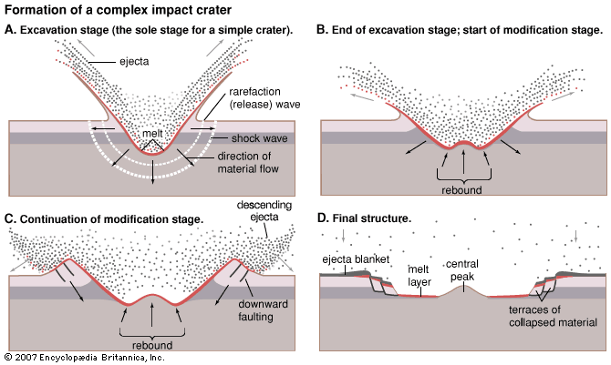
What is in the catalogue and how it is computed
From about 170 impact meteoritic craters on the Earth known according to literature and confirmed by geologists, the largest are listed in Table 1. We have computed the gravitational signals (gravity anomalies and gradients) at nearly all the localities mentioned in Table 1 and at some other promising places.| Name | Location | D [km] | t [My] |
| Vredefort | South Africa | 300 | 2020 |
| Sudbury | Ontario, Canada | 250 | 1850 |
| Chicxulub | Yucatán, Mexico | 170 | 65 |
| Popigai | den, Russia | 100 | 35.7 |
| Manicouagan | Quebec, Canada | 100 | 214 |
| Beaverhead | Idaho, USA | 100 | 900 |
| Acraman | South Australia, Australia | 90 | 590 |
| Chesapeake Bay | Virginia, USA | 90 | 35.5 |
| Puchezh-Katunki | Nizhny Novgorod, Russia | 80 | 167 |
| Morokweng | Kalahari Desert, South Africa | 70 | 145 |
| Kara | Nenetsia, Russia | 65 | 70 |
| Woodleigh | Western Australia, Australia | 60-120 | 364 |
| Tookoonooka | Queensland, Australia | 55 | 128 |
| Charlevoix | Quebec, Canada | 54 | 342 |
| Siljan | Dalarna, Sweden | 52 | 377 |
| Kara-Kul | Pamir Mountains, Tajikistan | 52 | 5 |
| Montagnais | Nova Scotia, Canada | 45 | 50 |
| Araguainha | Central Brasil | 40 | 244 |
| Mjolnir | Barents Sea, Norway | 40 | 142 |
| Saint Martin | Manitoba, Canada | 40 | 220 |
| Carswell | Saskatchewan, Canada | 39 | 115 |
| Clearwater West | Quebec, Canada | 36 | 290 |
| Manson | Iowa, USA | 35 | 73.8 |
Specifically, at the selected localities we computed (using software developed by Holmes et al., 2006) free air gravity anomaly ∆g and the second derivatives of the disturbing gravitational potential in the radial direction Tzz. Sometimes we computed other second derivatives (of the main diagonal of Marussi tensor) and the third anomalies Tzzz (in fact second derivatives of ∆g, as given by the program). In mountainous country all these signals may require topographic corrections to reveal better (partly) hidden structure.
The novelty of our approach is from (1) the use of a very detailed global combined gravitational field model EGM 08 (Pavlis et al., 2008 a, b), worked out by NASA and NGA (National Geospatial-Intelligence Agency) till degree and order 2190, with resolution 8 [km] cos φ on the ground (where φ is geodetic latitude) and (2), the computing two anomalous parameters of the gravitational field, the gravity anomaly ∆g and the second radial derivatives Tzz of that disturbing potential, not available from ground surveys. This second derivative has increased sensitivity to smaller features showing greater detail over the area surveyed. The third derivative should be still better for this purpose (Elkins 1951, Evjen 1936), but it suffers from anincreased noise.
The following quantities were computed: (1) “free-air gravity anomaly”, more precisely "spherically approximated gravity anomaly" ∆g = -∂T/∂r - 2T/r, where T is the disturbing gravitational potential T=V-U with the normal potential U, represented by Geodetic Reference System (Moritz 1984), and (2) the second derivatives of T on the main diagonal of the Marussi tensor, i.e. Txx, Tyy and Tzz - namely the second radial derivative Tzz ≈ Trr = ∂2 T / ∂ r2, where r is the geocentric radius of a general computation point. It should be always outside the sphere of radius R (scaling parameter of the EGM). All results presented here were computed at the zero height and 5’x 5’ angular grid.
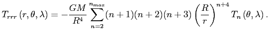
The gravity anomaly is defined:
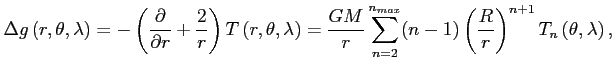
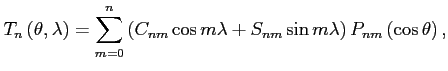
where R is radius of the Earth and Tn(θ, λ) is approximation of Tn (component of T) by spherical functions, n is degree of the harmonic expansion, (θ, λ) are co-latitude and longitude.
The second radial derivative of the disturbing gravitational potential in spherical approximation is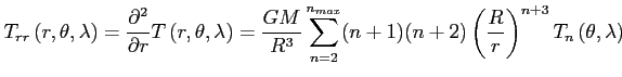
How the catalog is organized
Impacts are ordered within the particular continent in the small units. Each unit of the impact contains data and results by the scheme in (Fig. 1). Sometime the prescriped format is not kept, e.g. lake Bajkal (Asia panel) is here noted for better imagination of signal to noise ratio of the quantities mentioned above.
Futhermore the impact crater is identified by its name and approximate coordinates of its center (latitude and longitude East of Greenwich).
Then, we present satellite images (from various sources, often from Google Earth) and terrestrial data (like geological sketch, gravity anomalies, sometimes other data, but then we need more than one page per a locality).
Below and left we usually have gravity anomalies in miliGals, bottom right is typically reserved for the second radial derivatives in miliEotvos. Sometime we add other than radial second derivatives (always explained) or the third radial derivative.
| Satellite image | Geological map or other figures |
| ∆g [mGal] |
Tzz [mE] |
Note about the units used in our figures
gravity anomalies: 1 mGal = 10-5 ms-2; the second derivatives: 1 mE = 1 mili Eötvös = 10-12 s-2.Warning
The decision about any circular-like structure with promising gravity signal (whether it is or it is not an impact crater) is, however, on geologists. Geodesists and astronomer (the authors of this catalogue) can not decide themselves. Additional data is absolutely needed, information such as magnetic anomalies, seismic profiles and deposits of shock-metamorphic minerals (stishovite, coesit, diamond, etc), shatter cones, impact breccias, sueveit, shocked quartz, etc. must be added and a further search in situ is required.Acknowledgments
The doors to this research were opened thanks to an invitation by ESA, after accepting three our proposals of what to do with future GOCE data (following ESA’s AO from 2006). This work has been done in the frame of the grant # C 98056, provided kindly by ESA/PECS in 2007 and is partly supported also by project CEDR LC 506 of Ministry of Education of the Czech Republic. The authors are grateful to Nikolaos K. Pavlis and other authors of EGM 08 for this excellent gravity field model and also to Jianliang Huang, leader of the Evaluation team for PGM 2007A, for inviting us to cooperate within his group. We also thank S.A. Holmes, N. K. Pavlis and other co-authors of “A FORTRAN PROGRAM FOR VERY-HIGH-DEGREE HARMONIC SYNTHESIS” for providing this software, our basic computational tool. The ESA representative B. Zufferey, PECS Programme Manager, very kindly led our first steps within the grant from ESA PECS and helped us with necessary administrative tasks. Geologists Václav Cílek, Patrick Taylor, Jan Kutina, physical geographer Jan Kalvoda and geodesist (Ms) Ivanka Charvátová inspired us with their consultations.References
Elkins, T. A., The second derivative method of gravity interpretation, Geophysics 16, 29-50, 1951.
Evjen, H. A., The place of the vertical gradient in gravitational interpretation, Geophysics 1, 127-136, 1936.
Holmes S.A., et al. (2006) A FORTRAN PROGRAM FOR VERY-HIGH-DEGREE HARMONIC SYNTHESIS (HARMONIC_SYNTH), version 05/01/2006.
Huang J., Kotsakis C., Gruber T. (2007) Review of Evaluation Methods and Test Results for the Quality Assessment of Earth Gravity Models, IUGG XXIV, GS 002: Gravity field, Perugia; IAG/IGFS Joint Working Group, evaluation of the gravity field model PGM 2007A, http://users.auth.gr/~kotsaki/IAG_JWG.
Klokočník J. et al.: GOCE – specific tasks on fine gravity field structure of the Earth (Detection of hidden impact (meteoritic) structures), Technical Report Grant ESA/PECS C98056, 2008.
Klokočník J. et al.: Detection of Earth impact craters aided by a detailed global gravity field model EGM 08, Journal of Geodesy, submitted, 2008.
Klokočník J. et al.: EGM 08: Tests of the model and simulatitons for GOCE, Poster, presented at IAG Symposium "Gravity, Geoid & Earth Observation 2008", Chania, Crete, Greece, June 2008.
Moritz H.: Geodetic Reference System 1980. Bulletin Geodesique 58: 388-398, 1984.
Pavlis N.K., Holmes S.A., Kenyon S.C., Factor J.K. (2008a) An Earth Gravitational Model to Degree 2160: EGM 2008, presented at Session G3: "GRACE Science Applications", EGU Vienna.
Pavlis N.K., Holmes S.A., Kenyon S.C., Factor J.K (2008b) EGM2008: An Overview of its Development and Evaluation. Presented at IAG Int. Symp. GGEO 2008, 23-27 June 2008, Chania, Crete, Greece.
Pilkington N.K. et al.: Geophysics and Petrophysics of the Popigai Impact Structure, Siberia. In: Plado and Pesonen (eds.) 2002 - Impact in Precambrian shields.
Sharpton V. L., and 9 others: Chicxulub multiring impact basin: Size and other characteristics derived from gravity analysis. Science, 261: 1564-1567, 1993.
http://www.unb.ca/passc/ImpactDatabase/